


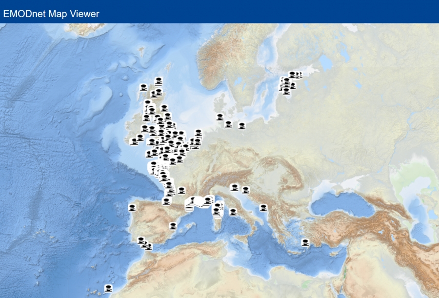
As coastal space across Europe becomes increasingly congested, governments are taking decisions on how to manage and allocate space at sea. This is one of the requirements of the 2014 EU Maritime Spatial Planning Directive and is increasing at pace with new offshore energy installations and aquaculture becoming prevalent across Europe’s seas.
If marinas and boating are not properly included in governance and maritime spatial planning discussions, their needs risk being overlooked. This could reduce the space available for recreational boating, limit access to the water, and create negative consequences for both boaters and the industry.
Currently, European marina data exists in a patchwork of proprietary navigation apps, national registries, and regional bodies, employing a variety of metrics, formats, and languages, which impedes effective cross-border aggregation and mapping.
EMODnet (European Marine Observation and Data Network) is an EU-funded consortium of national data centres, hydrographic surveys, geological surveys, marine research institutes, and biodiversity organisations from across Europe. Working together across seven themes: bathymetry, biology, chemistry, geology, physics, seabed habitats, and human activities, the platform aggregates and harmonises data into standardised, quality-controlled products, making this information publicly accessible at no cost for a wide variety of users.
EMODnet features an extensive range of blue economy activities such as ports, offshore wind farms, commercial shipping lanes, aquaculture, and protected natural marine areas, together with physical oceanographic data such as bathymetry and sea-level trends. As such it is a comprehensive reference source for mapping competing uses of coastal and marine space. Omitting marinas leaves planners without the relevant spatial layer needed to integrate recreational boating when allocating use of coastal waters.
Addressing the gap, Cogea BIP Group (leading the Human Activities thematic discipline for EMODnet), TransEurope Marinas, and European Boating Industry have partnered to start aggregating and harmonising basic marina data across Europe for display on the platform.
The first step was to agree an appropriate definition which included relevant dry-stack facilities with pontoons and excluded harbours without facilities. A capacity threshold of 50 berths was applied to identify significant facilities.
“A marina is a sheltered harbour or basin primarily intended for the secure berthing and landing of leisure craft. While occasionally accommodating commercial vessels, its main purpose is to serve recreational boating with tailored land and water facilities for participants.”
Thanks must go to the first associations to submit dataset contributions: Association of Estonian Marine Industries, the Fédération Française des Ports de Plaisance, The Yacht Harbour Association and TransEurope Marinas. These data can now be viewed on EMODnet website alongside OpenStreetMap points and polygons.
Considerable interest has been shown by further national bodies, currently developing their marina listings. Plans for the future include expanding coverage and widening the dataset to feature key marina services.
National associations, marina networks or other bodies are invited to support the recognition of recreational boating by submitting data for coastal and inland marinas (holding over 50 berths).
To submit your country's marina data or receive the standardised submission template, please contact Luigi Falco at Cogea: This email address is being protected from spambots. You need JavaScript enabled to view it. or EBI This email address is being protected from spambots. You need JavaScript enabled to view it..
For more information about this initiative, visit the EMODnet website.
 English
 Български
 Hrvatski
 Čeština
 Dansk
Dansk Nederlands
 Eesti
Eesti Suomi
Suomi Français
 Deutsch
 Ελληνικά
 Magyar
 Gaelige
 Italiano
 Latviešu valoda
 Lietuvių kalba
 Maltese
 Norsk bokmål
 Polski
 Português
 Română
 Русский
 Slovenščina
 Español
 Svenska